Exploratour - Mars Exploration
NASA/JPL
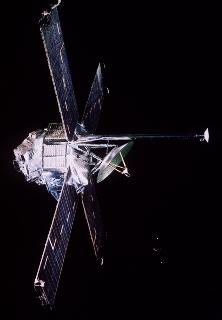
Mariner Missions
Mariner 4, 6, 7, and 9 took the first images of the volcanoes of Mars, including Olympus Mons, and others atop the Tharsis Ridge, and the south polar region.
The Mariner missions also measured the shape of Mars, made the first determination of the Martian buldge now called Tharsis Ridge, as well as making record of the strange fact that Mars is divided into two halves; old, elevated, northern terrain and yound, low, southern terrain. Most famously, Mariner 7 took the first close up images of the deep valley, which now bears its name, known as Valles Marineris.
The Mariner missions helped establish that, like the Moon, Mars had a barren surface with no running water. The vast number of craters helped establish that the surface of Mars was young compared to that of the Moon or Mercury, but nevertheless, very old when compared to that of the Earth.