Exploratour - The Surface of Mars
Click on image for full size
Image from: USGS
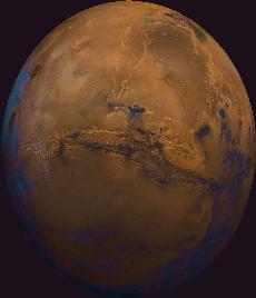
Valles Marineris
Valles Marineris is a large system of canyons, shown in this image, that stretches 4000 km (2500 mi) along the equator of Mars, and is up to 8 km deep. The first images of this canyon system were taken by Mariner 9 in the 1970's. As can be seen in the image, many huge, ancient river channels originate at north-central canyons and extend north. The three Tharsis volcanoes (dark red spots), each about 25 kilometers high, are visible on the leftmost (western) edge of the image. To the south are the highlands.
High resolution images returned by the Mars Global Surveyor spacecraft in 1999 have allowed closer examination of this unusual canyon. These images show steeply descending slopes, debris-filled gullies, with intervening rocky spurs. In this way the canyon resembles the Grand Canyon of Arizona or the Waimea Canyon on the island of Kauai. But the Grand Canyon formed from the flowing of water, a sedimentary process, while the Waimea Canyon formed from volcanic processes. Valles Marineris may have formed from either of these two geologic processes.
More study by scientists is needed to know for sure. In
either case, the total thickness of the layered rocks seen in
these images indicates that there may have been a complex and extremely active early
history for geologic processes on Mars.