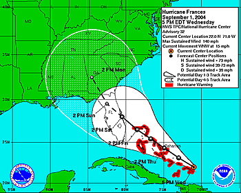
Map showing the projected path of Hurricane Frances (2004). Notice that the path becomes wider because there is more uncertainty about where the storm will go further in the future.
Click on image for full size
Courtesy of NOAA
Hurricane Forecasting Uses Climate Data to Predict the Season, and Weather Data to Predict a Storms Path
Each year scientists make predictions about the strength of the upcoming hurricane season. To make seasonal hurricane predictions, scientists look at climate models and climate events that are known to influence hurricane activity such as El Niño and La Niña. They take into account climate signals that last many decades and the sea surface temperatures, which may impact hurricane strength. While there is always some uncertainty in these predictions, they have become more accurate in recent years and scientists continue to explore how to improve them.
Lets imagine that a hurricane has formed and it is trundling across the ocean. How do we know where it will go? How do we know where it will hit the coast? The path of a hurricane depends on weather and so can only be estimated after a storm has formed. Meteorologists use powerful weather models that take current weather patterns into account, including the location of high and low pressure areas, to predict the path of a storm.
Scientists also have several ways to keep tabs on these storms to know if they are getting stronger or larger. When a storm is far out to sea, it can be monitored from above with weather satellites. Specially-equipped planes can also be flown into a hurricane to take measurements of pressure, wind, temperature, and other factors. Once it is close to land, Doppler radar is used to monitor the storm. Visual observations from land and measurements made with weather instruments become important as the storm approaches the coast.
Last modified October 5, 2009 by Lisa Gardiner.
You might also be interested in:

How did life evolve on Earth? The answer to this question can help us understand our past and prepare for our future. Although evolution provides credible and reliable answers, polls show that many people turn away from science, seeking other explanations with which they are more comfortable.
...more
Earth's ocean covers more than 70% of our planet's surface. There are five major ocean basins. The Pacific Ocean is the largest. It’s so large that it covers a third of the Earth's surface. The Atlantic
...more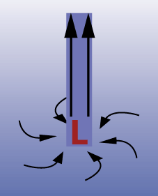
You may have seen a weather map with a red L on it. This red L denotes a low pressure system in that area of the map. Just what does that mean? The H for high pressure systems and alternatively the L for
...more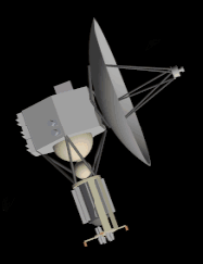
A satellite is any object that orbits around another, larger body, such as the Moon, which is a natural satellite of Earth. Over the past half century, we have figured out how to make new Earth satellites.
...more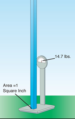
Pressure is an idea scientists use to describe how gases and liquids "push" on things. The atmosphere has pressure. If you imagine a column of air that is 1 inch square and goes from the Earth's surface
...more
The official "Hurricane Hunters" are the Air Force Reserve's 53rd Weather Reconnaissance Squadron. The squadron consists of ten WC-130 Hercules aircraft which are regularly flown through the eyes of hurricanes.
...more
A cyclone is an area of low pressure with winds blowing counter-clockwise around it in the Northern Hemisphere and clockwise around it in the Southern Hemisphere. A tropical cyclone is a cyclone which
...more
From the National Weather Service, Miami, Florida, 11 a.m. EDT: A hurricane warning remains in effect from Murrels Inlet, South Carolina to the North Carolina/Virgina border...Including Pamlico and Albemarle
...more