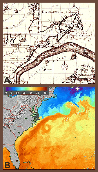
Click on image for full size
(A) The NOAA Photo Library and (B) NOAA
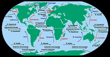
Picturing the Gulf Stream Current
When Benjamin Franklin was visiting England in 1769, he heard complaints from the British that mail boat heading to North America took weeks longer to get there than mail boat heading in the opposite direction from North America to Europe. As a postmaster in the American colonies, Benjamin Franklin took these complaints seriously. Franklin was also a scientist and so he turned to science to figure out what was going on with the mail delivery delay.
After crossing the Atlantic several times by boat, taking temperature measurements and making other observations of the ocean, Benjamin Franklin got to the bottom of the postal mystery discovering that the culprit was an ocean current that flowed from North America towards Europe. Boats going to Europe were quicker in the current. Boats going to North America were slowed by the current. He called the current the Gulf Stream.
Satellite images were was not available when Benjamin Franklin made his map of the Gulf Stream in 1770. His was the first map ever made of this ocean current - water that flows north along the east coast of the United States and then heads east towards Northern Europe. Mapping where this current was located allowed boats headed from the United States to Europe to stay in its path, speeding the journey.
Reflecting on his experience observing the Gulf Stream in a letter, Franklin wrote that, having since crossed this stream several times in passing between America and Europe, I have been attentive to sundry circumstances relating to it. He went on to note the things that he observed made the Gulf Stream waters different than other ocean waters, including a temperature difference. I find that it is always warmer than the sea on each side of it.
The warmer temperature of the Gulf Stream waters show up in satellite images of Sea Surface Temperature data (SSTs). Purple and blue represent the coldest water and orange and red represents the warmest water. The Gulf Stream is the warmest water in this satellite image. It reaches from the Caribbean to Delaware before heading east, amazingly the same location where Ben Franklin mapped the current by hand over two hundred years before.