Climate Change: Regional Impacts
Projected precipitation changes by the year 2100. Blue and green areas are expected to have more precipitation. Yellow and pink areas are projected to have less precipitation. The top image shows precipitation change during December, January, and February. The bottom image shows precipitation change during June, July, and August.Notice that high-latitudes are projected to have more precipitation while most low-latitude areas north and south of the equator are projected to have less precipitation.Image courtesy of the IPCC. |
Changes in Earth's climate have different effects in different areas of the world. Some place will warm much more than others; some regions will receive more rainfall, while others are exposed to more frequent droughts.
Let's begin to look at aspects of climate change that occur on regional, instead of global, scales. Keep in mind that the science of making regional predictions of future climate is still quite new, and such predictions should be taken with a grain of salt. However, improving climate models and faster supercomputers are expected to help climate scientists make rapid advances in this evolving field, so regional climate projections should improve dramatically in coming years.
Changing Regional Precipitation
Global average precipitation is expected to rise by about 3% to 5% by the year 2100 according to the IPCC Fourth Assessment Report. This increase is not, however, expected to be distributed evenly around the globe or throughout the seasons in a given year.
Much of the increase in precipitation is expected to occur at high latitudes. Many regions near the equator and at mid-latitudes are expected to actually see decreases in precipitation. Increased snowfall near both poles may offset some of the melting of glaciers and ice sheets in these regions by adding fresh ice to the tops of these features. Some places in Antarctica are even gaining more snow via increased precipitation than they are losing to melting caused by rising temperatures.
Some of the increased rainfall is expected to come in the form of more frequent heavy downpours. Some regions may receive a net increase in rainfall; but the increase may manifest itself as heavier rains punctuated by longer dry spells between these deluges. This change in precipitation patterns is likely to cause greater incidence of flooding, especially in combination with land use changes such as deforestation.
Many areas, especially in low- and mid-latitude regions, are expected to suffer from more frequent and more severe droughts. Dry conditions, warmer temperatures that produce longer "fire seasons", and changes to ecosystems are expected to generate more and larger wildfires in some areas.
Some presently dry regions may be glad to see increased rainfall, just as drier conditions may benefit some currently very wet places. However, heavy rainfall that causes flooding as well as extended or more frequent droughts are likely to be disruptive to ecosystems and agriculture in the afflicted regions.
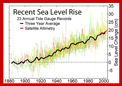
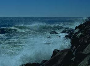
Low-lying Coastal Regions and Rising Seas
Not surprisingly, rising sea level is expected to have adverse effects on coastal regions and islands worldwide. However, the impacts will differ depending on the topography of the land and its susceptibility to flooding.
Some low-lying coastal regions will be subject to more frequent flooding or even permanent inundation. Large areas in the countries of Bangladesh and The Netherlands, along with the U.S. state of Florida and the city of New Orleans are only slightly above sea level, and thus are at great risk of even slight increases in sea level. Some small island nations in the Pacific are at such low elevations that they are in danger of being wiped off the map entirely as the water rises.
Higher sea levels will hasten erosion of beaches and other types of terrain along the shoreline. Salty water will seep further inland in estuaries and brackish marshes, altering ecosystems (many of which serve as nurseries for ocean-going fish and other aquatic creatures).
Teaching Resource: Mapping Ancient Coastlines gets learners mapping how sea level has affected a coastline in the geologic past.
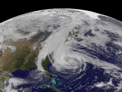
Hurricanes Prone Regions
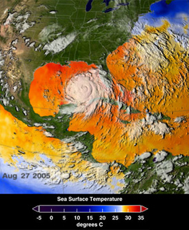 Regions of the world that are already prone to tropical cyclones (also known as hurricanes or typhoons) may see more impacts from them in the future. These storms derive their energy from warm ocean waters, so they may become more intense. The impact of warming on hurricanes is an active debate in the scientific community.
Hurricanes occur in six major regions worldwide: the North Atlantic, the Northeastern Pacific, the Northwestern Pacific, the Southwestern Pacific, and the North and South Indian Ocean. Each of these regions may be affected differently by changes to storm patterns caused by global warming. Hurricane seasons may start earlier and end later, providing more time for storms to occur. Storms may move into higher latitudes as ocean waters warm. Hurricanes may form in places where they hadn't before. For example, the unprecedented occurrence of Hurricane Catarina in the South Atlantic along the coast of Brazil in March 2004 may be an ominous portent of things to come.
Flooding from storm surge during hurricanes will wash further inland as sea level rises. Also, flooding from rapid rainfall during hurricanes may increase if the storms are able to carry more moisture because of increasing rates of evaporation.
Teaching Resource: The Hurricanes and Climate activity gets learners looking at hurricane data and how warming may be affecting the strength of storms.
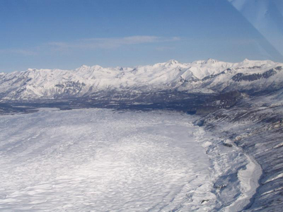
High Mountain Regions and Water
Almost all of the world's mountain or alpine glaciers are receding, a trend that is likely to continue in the years ahead. As glaciers shrink and in some places disappear, the human and natural communities in these regions may become quite parched for lack of glacial meltwater. In some regions, people depends almost entirely on glaciers for the water they use in towns, cities, and for agriculture. Much of northern India gets water from Himalayan glaciers, while large portions of Chile relies on glaciers in the Andes for water. Less water can lead to changes in ecosystems and greater incidence of water washed diseases. We will learn more about these impacts later in the course.
Regions Affected by El Niño and Other Patterns in the Atmosphere
Cycles such as El Niño and La Niña events and seasonal monsoons in India may change as climate warms. Scientists are still trying to improve models of these events, so predictions of how they may change in the future is somewhat speculative. Disruptions of the normal patterns, particularly of the monsoons, could affect many millions of people in areas like India and Bangladesh. El Niño and La Niña affect the Pacific Ocean and surrounding areas, but scientists are discovering that they also may have an influence on other areas of the world through teleconnections.
High Latitudes
The Arctic and parts of Antarctica are warming much more quickly than the global average, a trend that is expected to continue. The extent of sea ice in the Arctic Ocean has been decreasing rapidly; some models project complete loss of sea ice in the summertime in the Arctic by the middle of the 21st Century. Glaciers and ice sheets in Antarctica and Greenland are melting too. We will take a look at the impacts on the Greenland ice sheet in this week's readings.
Permafrost (frozen ground) usually provides a solid platform for buildings and roadways. It is solid enough for animals like caribou to migrate over. But thawing permafrost creates mushy ground, disrupting wildlife and human activities. Also, thawing of permafrost may release many gigatons of methane, a powerful greenhouse gas.
Teaching Resource: Graphing Sea Ice allows learners to explore how sea ice cover changes seasonally and over the past 30 years.
Images courtesy the National Snow and Ice Data Center (NSIDC). Animation by Windows to the Universe staff (Randy Russell). |