Click on image for full size
Kottek et al., 2006
Regional Climate
The climate at a given location on Earth is the regional climate. Regional climate depends on the temperature, precipitation, and winds experienced over the long term at that location. These characteristics are determined by other factors, including the latitude and altitude of the region, its topography, large scale atmospheric and oceanic circulation patterns, and the region's proximity to large bodies of water.
Regional climate is closely tied to latitude, because energy received at the surface of the Earth from the Sun is most direct at the equator and most indirect at the poles. Because of this, the energy from the Sun is spread out over more area at high latitude than at low latitudes. As a result, the energy per unit area at the equator is larger than it is at higher latitudes.
Another major factor determining the regional climate is the altitude of a region. In the Earth's troposphere - the lowest level of the atmosphere - temperature usually decreases with height (except in cases of temperature inversions), so that as you increase in altitude, the temperature decreases.
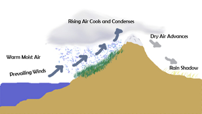
Topography, proximity to large bodies of water, and atmospheric and oceanic circulation patterns also have a significant impact on regional climate. For example, the presence of a mountain range will cause the region downwind of the mountain range to have less precipitation than the other side of the mountain. This is because mountains will cause lift in moist air masses carried by the prevailing winds, leading to precipitation on the side of the mountains facing the prevailing winds, leaving less moisture available for precipitation on the other side of the mountains. As a result, "rain-shadow deserts" are common on the downwind side of mountain ranges.
Water has a high heat capacity, which means that it is very effective at storing energy. Because of this, areas near the ocean or large lakes tend to have more moderate climates than regions that are far from large bodies of water. As a result, regions near the coast will tend to have smaller annual changes in temperature as a function of season than regions near the interior of continents, far from the moderating effects of the ocean.
Large scale circulation patterns in the ocean and atmosphere similarly can impact the regional climate. For example, the Gulf Stream, which carries warmth from the Caribbean up the Atlantic seaboard and up toward northern Europe is responsible for making the regional climate in the United Kingdom much more moderate than would otherwise be expected at that latitude.
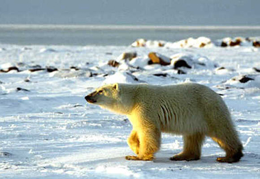
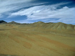
Regional climates have a strong influence on the types of plants and animals that can live in a particular area. Plants and animals have adapted to specific environmental conditions, so that while they might thrive in some regions, they may not be able to survive in others. For example, polar bears are well adapted to the high Arctic, but would not do well in the Atacama Desert. Similarly, tropical plants thrive in the hot and humid tropics, but cannot survive throughout the year without protection in areas where temperature drop below freezing.
In order to categorize regional climates, climate classification schemes have been developed. The figure shows one regional climate classification scheme developed by Wladimir Köppen originally in 1884. This scheme identifies five main climate regions (equatorial, arid, warm temperate, snow, and polar) modified by a variety of precipitation and temperature regimes. The map identifies regions based on this scheme - for example, the southeastern portion of the United States is identified as "Cfa" representing a "warm temperate" climate characterized as "fully humid" with "hot summers". The overall dependence of regional climates on latitude is evidenced by climate regions that span large bands of longitude (for instance, "Dfe" or "Bwh").