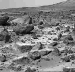
This image shows Rocks explored by the Rover.
Click on image for full size
Image from: JPL/NASA
Possible Origins of Rocks explored by the Rover
Unlike Earth where rivers can carry material for hundreds of miles, Martian rivers, which seem to be not very long at all, cannot transport material very long distances. The farthest a river may be able to carry a rock may be only 10's of kilometers.
Because many of the rocks seem to be similar, some scientists are presently guessing that the boulders may have been eroded from an outcropping 30 km away.
On the other hand, some of the weathering features found on the rocks may be signs that some of the rock originated as ejecta from the Big Crater located 2.2 kilometers to the south of the landing site.
You might also be interested in:
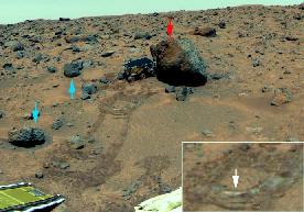
Even though the rocks seem to be much the same, scientists can see three basic differences in these rocks. These differences help them figure out more about weathering processes on Mars and where the soils
...more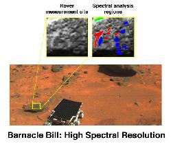
The rocks explored by the Mars Pathfinder's Rover are classified into two groups according to how they eroded. Rocks put in place as a result of an impact which forms a crater are usually much less eroded
...more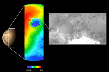
The Mars Odyssey was launched April 7, 2001, from Florida. After a six-month, 285 million-mile journey, the Odyssey arrived at Mars on October 24, 2001. The Odyssey is in its aerobraking phase right now.
...more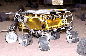
The Mars 2005 mission is still in the planning stages. It is set to launch in the year 2005.
...more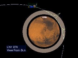
The Mars Global Surveyor reached Mars in September of 1997. But it didn't make it into its final mapping orbit until February 1999. What took so long? Surveyor needed to reach a near-circular, low-altitude
...more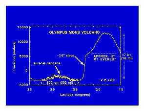
Mars Global Surveyor carries an instrument which measures the heights of things. This instrument is called an altimeter, or "altitude-meter". The graph to the left shows the results returned from Mars
...more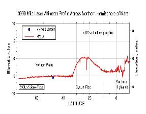
Mars Global Surveyor carries an instrument which measures the heights of things. This instrument is called an altimeter, or "altitude-meter". The picture to the left shows Mars Global Surveyor's measurement
...more