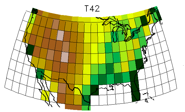
The frames of this animation illustrate spatial resolution of a model. The lowest resolution grid shown here, T42, covers most of the entire state of Florida with just two large grid cells. The highest resolution model, T340, uses dozens of grid cells to represent the many specific locations in Florida. High resolution model grids (like T340) allow us to predict future climate on a much finer scale, but require vastly more powerful supercomputers to run all of the required calculations. Lower resolution model grids (like T42) require much less computing power, but yield results with much less detail. Climate models of the mid-1990s typically used grids similar to T42, which has grid cells of about 200 by 300 km (120 by 180 miles) at mid latitudes. The T85 resolution is typical for the models used in the IPCC's Fourth Assessment Report (AR4); its grid cells are about 100 by 150 km (60 by 90 miles) across at mid latitudes. The T170 and T340 grids represent future directions in modeling as new, more powerful supercomputers come online in the years ahead. Such models will be able to produce projections for regional climates that will be much finer than those we can currently generate. Remember, atmospheric models (including climate models) also have grid cells in the vertical direction, representing the variations that come with altitude in Earth's atmosphere. The images shown here just depict resolution in latitude and longitude directions.
Images courtesy of Warren Washington, NCAR.