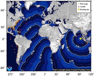
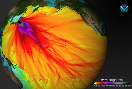
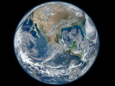
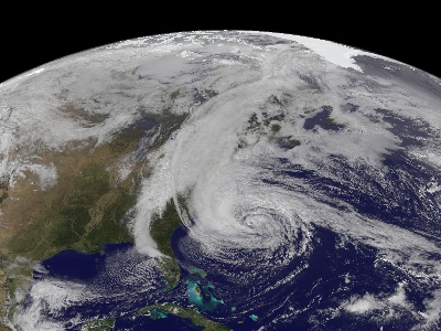
An <a href="http://earthquake.usgs.gov/earthquakes/recenteqsww/Quakes/usc000905e.php">8.6 magnitude earthquake</a> struck on 11 April 2012 off of Banda Aceh, Sumatra, Indonesia, followed by a strong aftershock.  Earthquake motion was primarily horizontal.  A tsunami warning was issued for the Indian Ocean, but was cancelled at 12:36 UTC.  A tsunami was observed at 1 meter or less. Find out more about <a href="/earth/geology/quake_1.html&edu=elem&dev=1/earth/Atmosphere/moons/h/neptune/transport.html">earthquake</a> and <a href="/earth/tsunami1.html&edu=elem&dev=1/earth/Atmosphere/moons/h/neptune/transport.html">tsunami</a> processes. Check out the resources <a href="/teacher_resources/2011_AGU-NESTA_GIFT_Workshop.html&edu=elem&dev=1/earth/Atmosphere/moons/h/neptune/transport.html">here</a>.<p><small><em>NOAA</em></small></p>The massive 9.0 magnitude <a href="/earth/geology/quake_1.html&edu=elem&dev=1/earth/Atmosphere/moons/h/neptune/transport.html">earthquake</a> off of Honshu, Japan on <a href="/headline_universe/march112011earthquaketsunami.html&edu=elem&dev=1/earth/Atmosphere/moons/h/neptune/transport.html">11 March 2011</a> generated a <a href="/earth/tsunami1.html&edu=elem&dev=1/earth/Atmosphere/moons/h/neptune/transport.html">tsunami</a> that exceeded 10 meters on the coast near the epicenter.  This image shows model projections for the tsunami wave height in cm which are in good agreement with the observed waves. Our thoughts and prayers are with those who were lost, and their families, as we remember this event.<p><small><em><a href="http://blogs.agu.org/wildwildscience/files/2011/03/680_20110311-TsunamiWaveHeight.jpg">NOAA Tsunami Wave Height Projections image</a></em></small></p>A new study has found that <a href="/earth/Atmosphere/airpollution_intro.html&edu=elem&dev=1/earth/Atmosphere/moons/h/neptune/transport.html">pollution</a> from <a href="/earth/Atmosphere/particulates.html&edu=elem&dev=1/earth/Atmosphere/moons/h/neptune/transport.html">fine particles</a> in the air - mainly the result of burning coal or <a href="/earth/interior/eruptions.html&edu=elem&dev=1/earth/Atmosphere/moons/h/neptune/transport.html">volcanic eruptions</a> - can shade <a href="/earth/Life/cnidarian.html&edu=elem&dev=1/earth/Atmosphere/moons/h/neptune/transport.html">corals</a> from sunlight and cool the surrounding water resulting in reduced growth rates.  Coral growth rates in the Caribbean were affected by volcanic aerosol emissions in the early 20th century and by aerosol emissions caused by humans in the later 20th century.  For more information, see the <a href="http://www.exeter.ac.uk/news/featurednews/title_278202_en.html">press release</a>.<p><small><em>Image courtesy of Toby Hudson (Wikimedia Commons)</em></small></p>This image is a montage of high resolutions photographs of the Earth taken in January 2012 by the Visible/Infrared Imager Radiometer Suite (VIIRS) instrument on the Suomi NPP satellite.  The image shows many stunning details of <a href="http://www.windows2universe.org/earth/earth.html">our home planet</a> - <a href="http://solarsystem.nasa.gov/multimedia/gallery/VIIRS_4Jan2012.jpg">particularly at high resolution</a>. The beauty of our planet is obvious from space - our blue <a href="http://www.windows2universe.org/earth/Water/overview.html">waters</a>, our white <a href="http://www.windows2universe.org/earth/Atmosphere/cloud.html">clouds</a>, and the green from <a href="http://www.windows2universe.org/earth/Life/life.html">life</a> abundant at the surface.<p><small><em>Image courtesy of NASA</em></small></p>An image of Hurricane Sandy taken by the GOES-13 satellite on October 28.  This category 1 <a href="/earth/Atmosphere/hurricane/hurricane.html&edu=elem&dev=1/earth/Atmosphere/moons/h/neptune/transport.html">hurricane</a> was huge, spanning a horizontal distance of about one-third the US continental landmass.  The storm came onshore in New Jersey, and gradually moved northeast.  The storm disrupted the lives of tens of millions in the eastern US, doing billions of dollars in damage, resulting in over 30 deaths.  Visit the National Hurricane Center's webpage on <a href="http://www.nhc.noaa.gov/">Hurricane Sandy</a> for details.<p><small><em>Image courtesy of NASA</em></small></p>Greenland's <a href="http://www.windows2universe.org/earth/polar/cryosphere_glacier1.html">ice sheet</a> saw a record <a href="http://www.windows2universe.org/headline_universe/olpa/greenland_10dec07.html">melt</a> in July 2012.  Scientists studying this event have found that this melting event was triggered by an influx of unusually warm air and amplified by the presence of a blanket of thin low-level <a href="http://www.windows2universe.org/earth/Atmosphere/cloud.html">clouds</a> which pushed temperatures up above freezing.  For more information see the <a href="http://www.news.wisc.edu/21638">press release</a> from the University of Wisconsin Madison.<p><small><em>Image courtesy of University of Wisconsin-Madison</em></small></p>

Windows to the Universe, a project of the National Earth Science Teachers Association, is sponsored in part is sponsored in part through grants from federal agencies (NASA and NOAA), and partnerships with affiliated organizations, including the American Geophysical Union, the Howard Hughes Medical Institute, the Earth System Information Partnership, the American Meteorological Society, the National Center for Science Education, and TERC. The American Geophysical Union and the American Geosciences Institute are Windows to the Universe Founding Partners. NESTA welcomes new Institutional Affiliates in support of our ongoing programs, as well as collaborations on new projects. Contact NESTA for more information. NASA ESIP NCSE HHMI AGU AGI AMS NOAA