Plate Tectonics
The following table discusses plate tectonics on Earth and Mars.
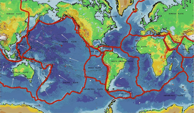
Earth
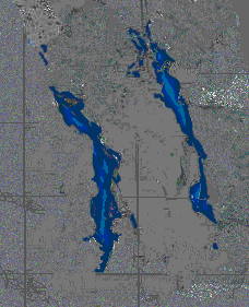
This animated diagram illustrates seafloor spreading on Earth.
Click on image for full size version (40K GIF)
Image courtesy of NOAA/NESDIS/National Geophysical Data Center, Boulder,
CO.
This animation shows how seafloor spreading works on
Earth. The age of
the ocean floor in the Atlantic and Pacific Oceans is shown in colors. The
animation shows that the American continents are
separated from the Eurasian and African continents as time advances. The
red sections are the
youngest portions of the ocean floor, where fresh new crust is added
from the deep interior of the Earth. The blue portions are the oldest
and are near regions of the Earth where subduction is taking place.
The red regions in the animation are associated with mid-ocean spreading
ridges. These are areas of the Earth's crust where the ocean floor is being
forced to spread apart. The continents drift along on top of the crust as it
spreads apart.
|
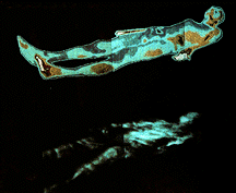
Mars
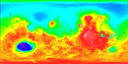
This is a map of the entire Martian surface.
Click on image for full size version (123K GIF)
Image courtesy of NASA.
As the map above shows, the elevated areas of the
Martian surface (colored in red) are concentrated on the southern
hemisphere of Mars. This would suggest that a single, large plate
has formed on Mars, with no subsequent plate
tectonics. |
 Leave the tour and read more about
Plate Tectonics.
Leave the tour and read more about
Plate Tectonics.
Leave the tour and read more about
the evolution of Mars.