Earth's Interior and Surface

Earth, the largest rocky planet, was formed about 4.5 billion years ago. The Earth's interior is divided into four layers which is typical of rocky planets. It is cool on the surface but very hot deep inside the planet. The center, or core, is as hot as 9000 degrees F.

The Earth's surface is unique from the other planets because it is the only one with liquid water. Water helps to make surface features such as rivers, lakes and oceans. The moving plates of the Earth’s surface form other surface features such as mountains, earthquakes and volcanoes.
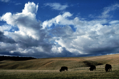
Bison roaming on mixed grass prairie - a type of <a
  href="/earth/grassland_eco.html&edu=elem&dev=1/windows.html">grassland</a>
  - at Wind Cave National Park (U.S.). Over one quarter of the Earth's surface
  is covered by grasslands. Grasslands are found on every continent except <a
  href="/earth/polar/polar_south.html&edu=elem&dev=1/windows.html">Antarctica</a>,
  and they make up most of Africa and Asia. Grasslands develop where there
  isn't enough rain for <a
  href="/earth/forest_eco.html&edu=elem&dev=1/windows.html">forests</a>
  but there is too much rain for <a
  href="/earth/desert_eco.html&edu=elem&dev=1/windows.html">deserts</a>.
  Grasslands are filled with - you guessed it - grass.<p><small><em>        National Park Service</em></small></p>Rainforest vegetation on the Caribbean island of Dominica. <a href="/earth/rainforest.html&edu=elem&dev=1/windows.html">Tropical
  rainforests</a> are home to thousands of species of animals, plants, fungi and
  microbes. Scientists suspect that there are many species living in
  rainforests have not yet been found or described. Rainforests get their name
  because they receive a lot of rain - an average of 80 inches (203 cm) a year!<p><small><em>     NBII Digital Image Library - Randolph Femmer, photographer</em></small></p>This is the Barringer Meteor Crater in Arizona. The diameter is 1.2
  kilomters, and it is 49,000 years old. Compared with other planets, <a
  href="/earth/Interior_Structure/crater.html&edu=elem&dev=1/windows.html">impact
  craters</a> are rare <a
  href="/earth/Interior_Structure/surface_features.html&edu=elem&dev=1/windows.html">surface
  features</a> on Earth. There are two main reasons for the low number of
  craters. One is that our <a
  href="/earth/Atmosphere/overview.html&edu=elem&dev=1/windows.html">atmosphere</a>
  burns up most <a
  href="/our_solar_system/meteors/meteors.html&edu=elem&dev=1/windows.html">meteoroids</a>
  before they reach the surface. The other reason is that Earth's surface is <a
  href="/earth/interior/plate_tectonics.html&edu=elem&dev=1/windows.html">continually
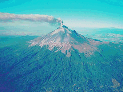
  active</a> and erases the marks of craters over time.<p><small><em>D. Roddy and LPI</em></small></p>The most majestic of the volcanoes are composite volcanoes, also
  known as strato-volcanoes. Unlike the <a
  href="/earth/interior/shield_volcanos.html&edu=elem&dev=1/windows.html">shield
  volcanoes</a> which are flat and broad, composite volcanoes are tall,
  symmetrically shaped, with steep sides, sometimes rising 10,000 feet high.
  They are built of alternating layers of <a
  href="/earth/interior/lava.html&edu=elem&dev=1/windows.html">lava</a>
  flows, volcanic <a
  href="/earth/interior/ash.html&edu=elem&dev=1/windows.html">ash</a>,
  cinders, blocks, and bombs. This is a photo of Mt. Cotopaxi in Ecuador.<p><small><em>The U.S. Geological Survey</em></small></p>Shortly after 5 am on the 18<sup>th</sup> of April in 1906, most people in
  San Francisco, CA were awoken by a sudden jolt. The Earth shook violently in
  a strong <a
  href="/earth/geology/quake_1.html&edu=elem&dev=1/windows.html">earthquake</a>.
  It lasted for only about a minute, but caused a lot of damage which destroyed
  much of the city. This photograph was taken just after an earthquake and
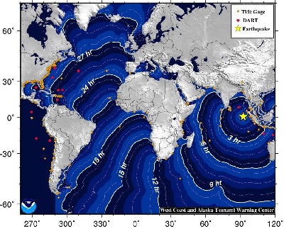
  fires had ravaged the city.<p><small><em>                                                    National Archives Still Picture Records Section, Special Media Archives</em></small></p>An <a href="http://earthquake.usgs.gov/earthquakes/recenteqsww/Quakes/usc000905e.php">8.6 magnitude earthquake</a> struck on 11 April 2012 off of Banda Aceh, Sumatra, Indonesia, followed by a strong aftershock.  Earthquake motion was primarily horizontal.  A tsunami warning was issued for the Indian Ocean, but was cancelled at 12:36 UTC.  A tsunami was observed at 1 meter or less. Find out more about <a href="/earth/geology/quake_1.html&edu=elem&dev=1/windows.html">earthquake</a> and <a href="/earth/tsunami1.html&edu=elem&dev=1/windows.html">tsunami</a> processes. Check out the resources <a href="/teacher_resources/2011_AGU-NESTA_GIFT_Workshop.html&edu=elem&dev=1/windows.html">here</a>.<p><small><em>NOAA</em></small></p>

Windows to the Universe, a project of the National Earth Science Teachers Association, is sponsored in part is sponsored in part through grants from federal agencies (NASA and NOAA), and partnerships with affiliated organizations, including the American Geophysical Union, the Howard Hughes Medical Institute, the Earth System Information Partnership, the American Meteorological Society, the National Center for Science Education, and TERC. The American Geophysical Union and the American Geosciences Institute are Windows to the Universe Founding Partners. NESTA welcomes new Institutional Affiliates in support of our ongoing programs, as well as collaborations on new projects. Contact NESTA for more information. NASA ESIP NCSE HHMI AGU AGI AMS NOAA