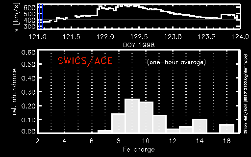
Radar image of the Los Angeles Basin
Click on image for full size
Image courtesy of NASA
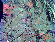
Click on image for full size
Image courtesy of NASA
Related links:
Los Angeles Heading for the Hills
News story originally written on October 28, 1998
Scientists have discovered that downtown and West Los Angeles appear to be
moving about one-fifth of an inch per year toward the San Gabriel
Mountains.
The measurements were made using the Southern California Integrated Global
Positioning System Network (SCIGN), a network of GPS satellites that can
detect tiny movements in earthquake faults across Southern
California. The system uses radio signals from 24 different GPS
satellites to pinpoint the locations of ground receiver stations within 0.4
inches. There are currently about 60 receiver stations in the greater Los
Angeles area; ultimately there will be 250 stations.
"We've known for some time that the area between the coastline and the
Mojave Desert is being squeezed together by the constant movement of the
Earth's crust," said Dr. Donald Argus, a geophysicist at JPL.
The project is designed to monitor the slow, small movement of the ground in
Southern California. "This research helps us learn where earthquakes are
more likely to happen, and helps with estimating the regional earthquake
hazard in Southern California," said Dr. Dr. Frank Webb, chair of the SCIGN.
Last modified February 26, 2007 by Lisa Gardiner.