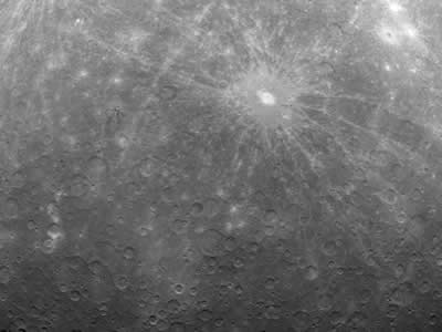
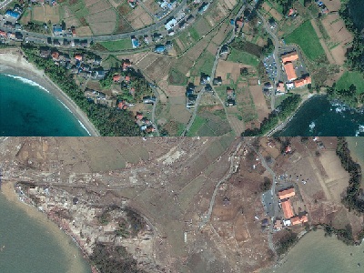
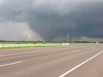
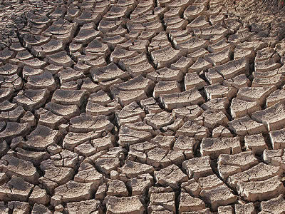
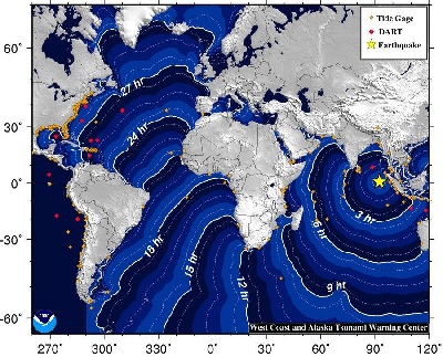
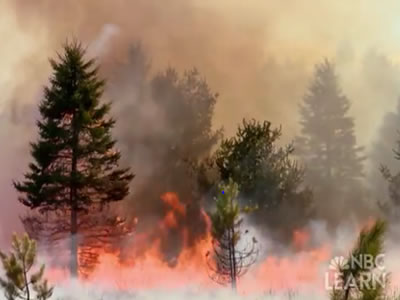
This historic image is the first ever taken from a spacecraft in orbit about <a href="/mercury/mercury.html&edu=high&dev=1/k=/h/neptune/=/earth/Windows_GIFT_AGU_2007-1.pps">Mercury</a>, the innermost planet of the solar system.  Taken on 3/29/2011 by <a href="/space_missions/robotic/messenger/messenger.html&edu=high&dev=1/k=/h/neptune/=/earth/Windows_GIFT_AGU_2007-1.pps">MESSENGER</a>, it shows numerous craters across the <a href="/mercury/Interior_Surface/Surface/surface_overview.html&edu=high&dev=1/k=/h/neptune/=/earth/Windows_GIFT_AGU_2007-1.pps">surface</a> of the planet.  Temperatures there can reach over 800F because Mercury is so close to the Sun and rotates so slowly.  MESSENGER entered orbit around Mercury earlier in March 2011.<p><small><em>NASA/Johns Hopkins University Applied Physics Laboratory/Carnegie Institution of Washington</em></small></p>March 2012 marks the first anniversary of the 9.0 magnitude <a href="/earth/geology/quake_1.html&edu=high&dev=1/k=/h/neptune/=/earth/Windows_GIFT_AGU_2007-1.pps">earthquake</a>, <a href="/earth/tsunami1.html&edu=high&dev=1/k=/h/neptune/=/earth/Windows_GIFT_AGU_2007-1.pps">tsunami</a>, and resulting nuclear accident in Japan on <a href="/headline_universe/march112011earthquaketsunami.html&edu=high&dev=1/k=/h/neptune/=/earth/Windows_GIFT_AGU_2007-1.pps">11 March 2011</a>.  The tsunami did massive damage, wiping out entire villages and killing ~16,000 people, and leading to one of the most serious nuclear accidents in history.  This image shows before and after photos of the area north of Sendai, where 10,000 people were lost.<p><small><em>Photos by <a href="http://www.nytimes.com/interactive/2011/03/13/world/asia/satellite-photos-japan-before-and-after-tsunami.html?hp">GeoEye/EyeQ</a>.</em></small></p>On May 20, 2013, a massive EF5 <a href="http://www.windows2universe.org/earth/Atmosphere/tornado.html">tornado</a> hit Moore, Oklahoma, devastating communities and lives.  The tornado, on the ground for 40 minutes, took a path through a subdivision of homes, destroying block after block of homes, and hitting two elementary schools just as school was ending as well as a hospital. Hundreds of people were injured, and 24 were killed.<p><small><em>Image courtesy of Ks0stm, Creative Commons Attribution-Share Alike 3.0 Unported license</em></small></p>As temperatures rise and soil moisture decreases, plants are stressed, which can lead to <a href="/earth/climate/crops_withering.html&edu=high&dev=1/k=/h/neptune/=/earth/Windows_GIFT_AGU_2007-1.pps">crop withering</a>. <a href="/teacher_resources/online_courses/health/events_health.html&edu=high&dev=1/k=/h/neptune/=/earth/Windows_GIFT_AGU_2007-1.pps">Droughts</a> accompanied by increased temperatures can lead to famine, social and political disruptions. Scientists are  helping with early identification of drought that might trigger food shortages. Watch the NBC Learn video - <a href="/earth/changing_planet/withering_crops_intro.html&edu=high&dev=1/k=/h/neptune/=/earth/Windows_GIFT_AGU_2007-1.pps">Changing Planet: Withering Crops</a> to find out more.<p><small><em>Image taken by Tomas Castelazo, Creative Commons <a href=&quot;http://creativecommons.org/licenses/by/3.0/deed.en&quot;>Attribution 3.0 Unported</a> license.</em></small></p>An <a href="http://earthquake.usgs.gov/earthquakes/recenteqsww/Quakes/usc000905e.php">8.6 magnitude earthquake</a> struck on 11 April 2012 off of Banda Aceh, Sumatra, Indonesia, followed by a strong aftershock.  Earthquake motion was primarily horizontal.  A tsunami warning was issued for the Indian Ocean, but was cancelled at 12:36 UTC.  A tsunami was observed at 1 meter or less. Find out more about <a href="/earth/geology/quake_1.html&edu=high&dev=1/k=/h/neptune/=/earth/Windows_GIFT_AGU_2007-1.pps">earthquake</a> and <a href="/earth/tsunami1.html&edu=high&dev=1/k=/h/neptune/=/earth/Windows_GIFT_AGU_2007-1.pps">tsunami</a> processes. Check out the resources <a href="/teacher_resources/2011_AGU-NESTA_GIFT_Workshop.html&edu=high&dev=1/k=/h/neptune/=/earth/Windows_GIFT_AGU_2007-1.pps">here</a>.<p><small><em>NOAA</em></small></p><p>Something on Earth is always burning! NASA's Earth Observatory tracks wildfires across the world with <a href="http://earthobservatory.nasa.gov/GlobalMaps/view.php?d1=MOD14A1_M_FIRE" target="_blank">maps available for viewing</a> from 2000-present. Some wildfires can restore <a href="/earth/ecosystems.html&edu=high&dev=1/k=/h/neptune/=/earth/Windows_GIFT_AGU_2007-1.pps">ecosystems</a> to good health, but many can threaten human populations, posing a natural disaster threat.</p>
<p>Check out the materials about natural disasters in <a href="/earth/natural_hazards/when_nature_strikes.html&edu=high&dev=1/k=/h/neptune/=/earth/Windows_GIFT_AGU_2007-1.pps">NBC Learn Videos</a>, and their earth system science connections built up by the related secondary classroom activities.</p><p><small><em>NBC Learn</em></small></p>

Windows to the Universe, a project of the National Earth Science Teachers Association, is sponsored in part is sponsored in part through grants from federal agencies (NASA and NOAA), and partnerships with affiliated organizations, including the American Geophysical Union, the Howard Hughes Medical Institute, the Earth System Information Partnership, the American Meteorological Society, the National Center for Science Education, and TERC. The American Geophysical Union and the American Geosciences Institute are Windows to the Universe Founding Partners. NESTA welcomes new Institutional Affiliates in support of our ongoing programs, as well as collaborations on new projects. Contact NESTA for more information. NASA ESIP NCSE HHMI AGU AGI AMS NOAA