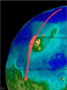
The Mars Global Surveyor spacecraft measures The Tharsis Ridge.
Click on image for full size
NASA/JPL
Altimetry
Altimetry is a term which describes a method of measuring the altitudes of things with remote spacecraft. It is usually performed with a laser. Laser altimeters bounce beams of light from the surface and back to the spacecraft to measure the heights of mountains and depths of valleys on remote planets. This is even done for our own planet. The figure shown here shows laser altimeter results from the Mars Global Surveyor spacecraft. The red line shows the relative altitudes of the terrain underneath. Other measurements from Mars include such features as Olympus Mons, the bluff separating the southern and northern hemispheres, and other features.
You might also be interested in:
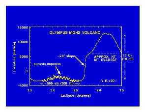
Mars Global Surveyor carries an instrument which measures the altitudes of things. The instrument is called an altimeter, or "altitude-meter". The graph to the left shows the results returned from Mars
...more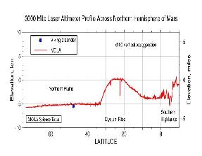
Mars Global Surveyor carries an instrument which measures the altitudes of things. The instrument is called an altimeter, or "altitude-meter". The graph to the left shows Mars Global Surveyor's measurement
...more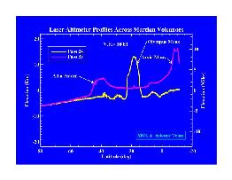
Mars Global Surveyor carries an instrument which measures the altitudes of things. The instrument is called an altimeter, or "altitude-meter". The graph to the left shows Mars Global Surveyor's measurement
...more
Mars Global Surveyor (MGS) is conducting mapping operations at Mars more than 30 years after America's first reconnaissance missions reached the mysterious red planet. Here are some of the instruments
...more
AU stands for Astronomical Units. Distances in space are too large to measure in Earth standards like miles or kilometers. For distances too large to measue in AU, we use light years. A light year is the
...more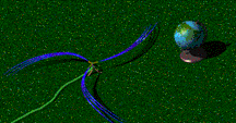
The solar wind is formed as the Sun's topmost layer blows off into space carrying with it magnetic fields still attached to the Sun. Gusts and disturbances form in the solar wind associated with violent
...more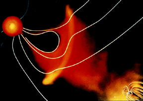
For a planet to be affected by a blob of material being ejected by the sun, the planet must be in the path of the blob, as shown in this picture. The Earth and its magnetosphere are shown in the bottom
...more