Click on image for full size
Courtesy of NCAR
Sea-level Rise May Pose Greatest Threat to Northeast U.S., Canada
News story originally written on May 27, 2009
The melting of the Greenland ice sheet this century may drive more water than previously thought toward the already threatened coastlines of New York, Boston, Halifax and other cities in the northeastern United States and Canada, according to new research.
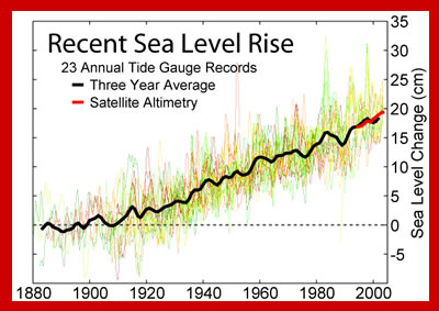
Results of the study are being published this week in Geophysical Research Letters. They suggest that moderate to high rates of ice melt from Greenland may shift ocean circulation by about 2100, causing sea levels off the northeast coast of North America to rise by about 30 to 51 centimeters (12 to 20 inches) more than other coastal areas.
The research builds on recent reports that have found that sea level rise could adversely affect North America, and its findings suggest that the situation is even more urgent than previously believed.
"If the Greenland melt continues to accelerate, we could see significant impacts this century on the northeast U.S. coast from the resulting sea level rise," says scientist Aixue Hu, the paper's lead author. Hu is at the National Center for Atmospheric Research (NCAR) in Boulder, Colo. "Major northeastern cities are directly in the path of the greatest rise."
A study in Nature Geoscience in March warned that warmer water temperatures could shift ocean currents in a way that would raise sea levels off the Northeast by about 20 centimeters (8 inches) more than the average global sea level rise that is expected with global warming.
But it did not include the additional impact of Greenland ice, which at moderate to high melt rates would further accelerate changes in ocean circulation and drive an additional 10 to 30 centimeters (4 to 12 inches) of water toward northeastern North America on top of the average global rise.
The new research was funded by the U.S. Department of Energy and by NCAR's sponsor, the National Science Foundation (NSF). It was conducted by scientists at NCAR, the University of Colorado at Boulder, and Florida State University.
To assess the impact of Greenland ice melt on ocean circulation, Hu and his coauthors used the Community Climate System Model, an NCAR-based computer model that simulates global climate.
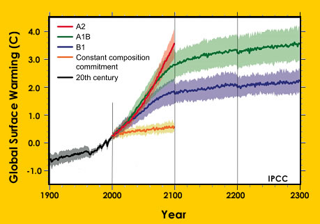
They considered three scenarios: the melt rate continuing to increase by 7 percent a year, as has been the case in recent years, or the melt rate slowing down to an increase of either 1 or 3 percent a year.
If Greenland's melt rate slows down to a 3 percent annual increase, the study team's computer simulations indicate that the runoff from its ice sheet could alter ocean circulation in a way that would direct about a foot of water toward the northeast coast of North America by 2100.
This would be on top of the average global sea level rise expected as a result of global warming. Although the study team did not try to estimate that mean global sea level rise, their simulations indicated that melt from Greenland alone under the 3 percent scenario could raise sea levels by an average of 53 centimeters (21 inches).
If the annual increase in the melt rate dropped to 1 percent, the runoff would not raise northeastern sea levels by more than the 20 centimeters (8 inches) found in the earlier study in Nature Geoscience.
But if the melt rate continued at its present 7 percent increase per year through 2050 and then leveled off, the study suggests that the northeast coast could see as much as 51 centimeters (20 inches) of sea level rise above a global average that could be several feet.
However, Hu cautioned that other modeling studies have indicated that the 7 percent scenario is unlikely.
In addition to sea level rise, Hu and his co-authors found that, if the Greenland melt rate were to defy expectations and continue its 7 percent increase, this would drain enough fresh water into the North Atlantic to weaken the oceanic circulation that pumps warm water to the Arctic.
Ironically, this weakening of the meridional overturning circulation would help the Arctic avoid some of the warmed ocean impacts of global warming and lead to at least the temporary recovery of Arctic sea ice by the end of the century.
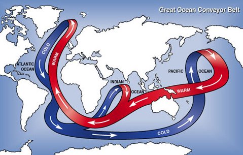
The northeast coast of North America is especially vulnerable to the effects of Greenland ice melt because of the way the meridional overturning circulation acts like a conveyer belt transporting water through the Atlantic Ocean.
The circulation carries warm Atlantic water from the tropics to the north, where it cools and descends to create a dense layer of cold water. As a result, sea level is currently about 71 centimeters (28 inches) lower in the North Atlantic than the North Pacific, which lacks such a dense layer.
If the melting of the Greenland Ice Sheet were to increase by 3 percent or 7 percent yearly, the additional fresh water could partially disrupt the northward conveyor belt.
This would reduce the accumulation of deep, dense water. Instead, the deep water would be slightly warmer, expanding and elevating the surface across portions of the north Atlantic.
"The oceans will not rise uniformly as the world warms," says NCAR scientist Gerald Meehl, a co-author of the paper. "Ocean dynamics will push water in certain directions, so some locations will experience sea level rise that is larger than the global average."
Text above is courtesy of the National Science Foundation