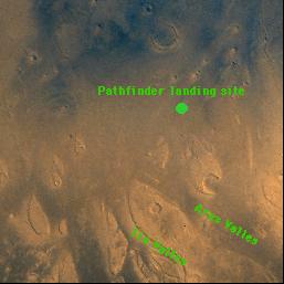
This image shows the landing site for the Mars Pathfinder mission.
Click on image for full size
Image from: NASA/JPL
Ares Vallis
Mars Pathfinder touched down in what appeared to be the remains of a catastrophic flood. Thus, scientists had the opportunity to study what is thought to be a surface created by flowing water.
A map of the region, shown here, shows the Ares and Tiu valleys. Ares is the Greek name of the god of War, also called Mars by the Romans. Read about the god Ares below. Ares Vallis means "Ares Valley". These valleys are to be found on the north-eastern edge of Xanthe Terra (look at the large map of Mars to see Xanthe Terra).
The picture shows tear-dropped shaped tails around some of the craters in the area. These tails indicate that there might have been a lot of flowing water in the area in the past. The tails are part of the reasons why scientists think the region is an valley created by a catastrophic flood.
On the web page linked in at the bottom of this page one may create your own map of the region and see the channels relative to where Pathfinder landed. Connecting to this web-site is recommended. Once linked, a map is shown which shows the Mars Pathfinder landing site. Click on the landing site location and create your own map. Then use the (-) button to zoom out and view the landing site from a greater distance.
You might also be interested in:
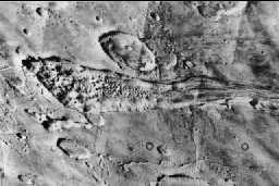
On Mars there are the remains of many tear-drop shaped lakes such as the one shown in this image. Most of these are found near the Martian volcanoes. They are really channels where water once gushed forth.
...more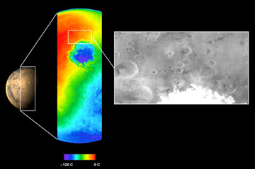
The Mars Odyssey was launched April 7, 2001. After a six-month journey, the Odyssey arrived at Mars on October 24, 2001. The instruments onboard the Mars Odyssey will study the minerals on the surface
...more
The Mars 2005 mission is still in the planning stages. It is set to launch in the year 2005.
...more
Aerobraking slowed the Mars Global Surveyor down when it reached Mars. Aerobraking also helped MGS to get into the right orbit for mapping the surface of Mars. Aerobraking means that the MGS flew through
...more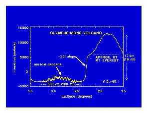
Mars Global Surveyor carries an instrument which measures the heights of things. This instrument is called an altimeter, or "altitude-meter". The graph to the left shows the results returned from Mars
...more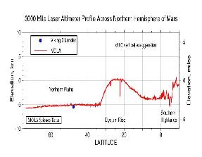
Mars Global Surveyor carries an instrument which measures the heights of things. The picture to the left shows Mars Global Surveyor's measurement of the size of the giant cliff which separates the southern
...more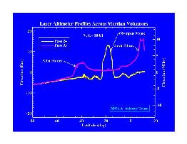
Mars Global Surveyor carries an instrument which measures the heights of things. The picture to the left shows the results returned from Mars Global Surveyor's measurement of the size of some of the Martian
...more