This drawing shows a cross-section of the Martian frozen ground.
Click on image for full size
NASA
The Martian Cryosphere
The drawing shows a crossection of the crust, and the unusual altitude variation of the Martian surface. The figure illustrates the depth of frozen ground at various latitudes, called the cryosphere.
The Martian geography is one of high altitudes at high southern latitudes and low altitudes near the equator. The ground is less frozen at the lower latitudes because it is warmer near the equator and water can evaporate. Thus, the frozen ground is only 2.5 km deep at the Martian equator while it is 6 km deep at the south pole.
To have liquid water running on the surface of Mars, the water region must be exposed to the surface. This may have happened at various times in the history of Mars as the climate changed.
You might also be interested in:
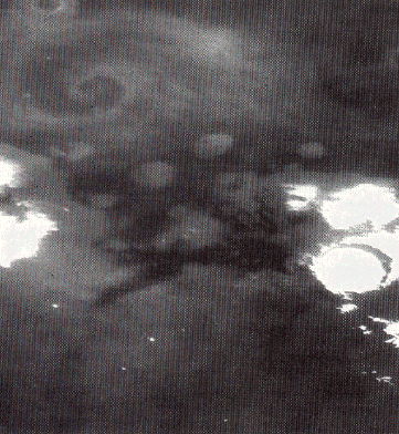
This is an image of a storm moving across the Martian terrain. The camera is looking down upon the storm and the storm front forms a spiral pattern, the same way terrestrial storms are presented on the
...more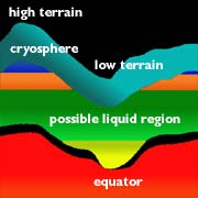
On Mars, the water is trapped, frozen, within the ground. Nevertheless, there is evidence for running water on Mars. When the water is melted and released to the surface, it will run from higher ground
...more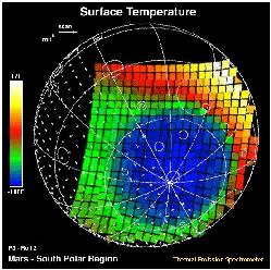
This image shows how cold the surface of Mars can be. The temperature was measured by the Mars Global Surveyor spacecraft. The scale to the left shows that purple regions are the coldest, about -170 degrees
...more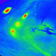
On this map of Mars, the lightly cratered Tharsis Ridge is shown, as well as the heavily cratered Martian highlands (near the bottom of the picture), and Valles Marineris to the right. The volcanoes are
...moreThe drawing shows a crossection of the crust, and the unusual altitude variation of the Martian surface. The figure illustrates the depth of frozen ground at various latitudes, called the cryosphere. The
...more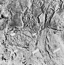
Separate from the Martian outflow channels, or the river valley networks, are large Martian lakes (600 km, or ~1000 miles across) which exhibit evidence of a periodic and catastrophic release of water
...more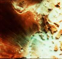
This is an image of fog in a Martian canyon. The presence of fog provides evidence of water, and a water cycle on Mars. More fog has been seen in images returned by Mars Global Surveyor of the south polar
...more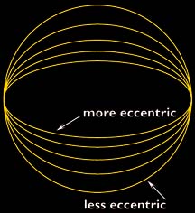
The Martian climate is more influenced by the shape of the Martian orbit than the climate of the Earth is influenced by the shape of the Earth's orbit. The orbit of Mars is more oval-shaped than that
...more


