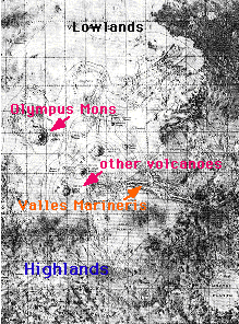
This map shows a portion of the surface of Mars.
Click on image for full size
Image from: NASA
Martian Global Geography
The surface of Mars consists of highlands and lowlands. The highlands are in the southern hemisphere (the bottom of the figure), and the lowlands are in the northern hemisphere of Mars (top of the figure). The lowlands contain the
Tharsis Ridge, where many of the largest
volcanoes of Mars are located. Next to the Tharsis Ridge is
Valles Marineris, a very long canyon of Mars. The high resolution topographic map, which can be viewed by clicking on the image to the left, shows these regions in better detail. Measurements returned by Mars Global surveyor demonstrate the
severe height difference between these two regions of Mars.
The highlands have tons of craters. They are the oldest portion of Mars. The lowlands are younger and so do not contain as many craters as the highlands.
Not seen clearly in this image are the Martian polar caps. Besides ice, the southern polar region of Mars contains other interesting geologic features such as layered terrain and giant sanddunes. This region was suppose to be explored by the Mars '98 mission.
You might also be interested in:

How did life evolve on Earth? The answer to this question can help us understand our past and prepare for our future. Although evolution provides credible and reliable answers, polls show that many people turn away from science, seeking other explanations with which they are more comfortable.
...more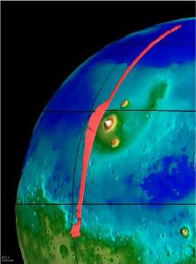
This image, taken from the Mars Global Surveyor mission (MGS), shows the Tharsis Ridge, the green/blue area in the middle of the picture, as well as a portion of the southern hemisphere of Mars. The green
...more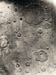
This is an example of the cratered surface of Mars. Almost the entire surface of Mars is covered with craters. Craters can be wiped out over time, so a surface which has many craters is very old. The lowlands
...more
The North and South Poles on Mars are a lot like the polar regions on Earth. They are the coldest places on the planet. The temperatures in the winter can drop to -150° C (about -238° F). Both poles have
...more
The Mars '98 mission was supposed to study the climate, weather, and surface at the Martian south pole. Mars '98 was to build upon the discoveries of the Mars Pathfinder and Mars Global Surveyor missions
...more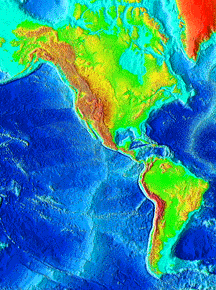
This image of the surface of the Earth shows the North and South American continents, as well as the floor of the Pacific Ocean. As can be seen in the image, the ocean floor shows evidence of mid-ocean
...more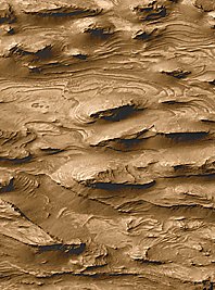
The Mars Global Surveyor (MGS) was launched on November 7, 1996. It has been in orbit around Mars for over 1500 days. It may have made its greatest observation this month! Pictures taken by the camera
...more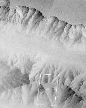
After decades of exploration of Mars, many questions still remain. What happened to the water on Mars? Has all the water escaped is it hidden in the ground and polar caps? What is the present and past
...more