The Geography of Land Planning
| Summary: |
Students use simplified maps to plan towns, being conscious of water resources, and then learn how their town fits into the larger community. | Materials:
|
| Source: |
The Ecoreach Program at University of Georgia and the Colorado Mountain Club. | |
| Grade level: |
4-9 | |
| Time: |
One-time prep: 2 hours; Class time: 30-50 minutes | |
|
Student Learning Outcomes:
|
|
|
| Lesson format: |
Hands-on activity with follow-up group discussion | |
| Standards Addressed: |
|
DIRECTIONS:
Preparation: (Note: This activity required a few hours of preparation before the first time you do it, but the supplies may last for many years and so future use requires little to no supply preparation.)
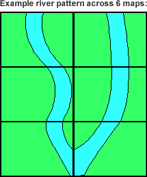
- Arrange the 6 sheets of green poster board next to each other in a grid pattern that is three sheets long (short dimension) by two sheets wide (long dimension).
- Label the back side, upper left corner of each square so that you remember where it goes in the grid (Example: The first sheet in the top row could be labeled “1A” for row 1 column A.)
- Sketch a river over the poster boards. The river should meander through each board taking up about a quarter of the space on each board. (See diagram example.)

- Cut the blue poster board into pieces that are the shape of the river segment on each board and glue them where you have sketched the river. Indicate some wetland areas with a blue marker on the green posterboard.
- Use Template 1 and Template 2 to make houses, power plants, markets, farms, parks, schools, apartment buildings, post offices, dumps and other items out of construction paper. Six sets will be needed. Place each set in a bag. Each set doesn't need to have exactly the same number of each item, but they should all have enough items so that some thought will have to go into town planning to fit everything in nicely. Make sure most of the structures in each set are dwellings.
- It is recommended that you laminate the construction paper buildings as well as the large sheets of poster board. Not only will lamination allow the supplies to last longer, but it will also allow students to use vis-à-vis markers to draw roads, additional buildings (arcades, skate parks, malls, zoos, or whatever they would like in their town). The vis-a-vis markers will wash off lamination easily with a wet paper towel.
In Class:
- Have posterboards arranged into a stack (so that students do not suspect they all fit together) and introduce the concept of land planning. If possible, show students a copy of your area’s land plan (available from city planners).
- Show students one of the green posterboard maps. Point out the waterway and wetlands. Show students the construction paper buildings. Tell students that their challenge is to work in a group to plan a town that they would want to live in. The town needs to contain everything in the bag of supplies (and more items as they wish), and planning needs to protect water resources.
- Divide students into 6 groups and assign a poster board map, a bag of supplies and a vis-à-vis marker to each group. Allow groups 20 or so minutes to make their towns. Allow them the freedom to add items they would want in their town. Have students secure laminated buildings to laminated poster board with masking tape. (Make sure they also make a welcome sign with a town name on it.)
- Take 5-10 minutes to have each group briefly present their town to the others. Tell their town name and why they think their town is cool.
- Place boards in grid order on the floor and organize students into a circle around them. Ask students if they knew what was off the edges of their map? How do nearby towns affect planning? Ask students if they are satisfied with how nearby towns have been planned. Which way does the river flow? Does pollution from towns upstream affect the portion of the river within downstream towns?
- Discussion: Brainstorm ways in which towns can cooperate. Have student groups negotiate with other towns to improve overall planning.
ASSESSMENT:
Have student groups write a proposal letter to leaders of neighboring towns about what they would like to see changed and why.
BACKGROUND INFORMATION:
The saying, "your rights end where the other persons nose begins" describes, in simple terms, how our legal system often defines the limits of our freedoms, However, in many cases, including land planning, actions in one community affect another without "noses" ever seeming to come into contact. Towns may affect other towns without even stepping off their property. For instance, a power plant upstream may contaminate the water downstream. A trash dump planned in one town to avoid the densely populated sections, may wind up adjacent to the next-door town's park.
This activity not only touches on the importance of land planning, water and wetland conservation, but it also illustrates an important concept in mapping. That is, what is beyond the edges of your map can be very
important. Hopefully students are encouraged by this activity to "think outside the map"!
This activity can be adapted to fit the needs of teachers covering social studies, water rights, conservation, watershed science, or geography curriculum. It is flexible enough to form at a variety of levels and classroom formats.
RELATED SECTIONS OF THE WINDOWS TO THE UNIVERSE WEBSITE:
OTHER RESOURCES:


