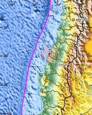
Courtesy of USGS
Massive Earthquake Shakes Chile
News story originally written on February 27, 2010
Early Saturday morning, February 27, 2010, a very strong earthquake shook Chile and western South America. The earthquake, a magnitude 8.8, struck about 100 km (60 mi) off the coast of Maule, Chile (see map at left). The depth of the earthquake was 35 km (21.7 mi). People living in the area have been feeling the shaking of numerous strong aftershocks too.
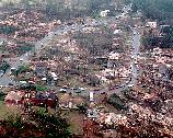
The magnitude of this earthquake was strong enough to reduce buildings and bridges to rubble and disrupt power. The earthquake epicenter was not far from the large cities of Santiago and Conception, Chile. Approximately 1.5 million people are now homeless in the earthquake region of coastal Chile, according to the director of Chilean emergency management office.
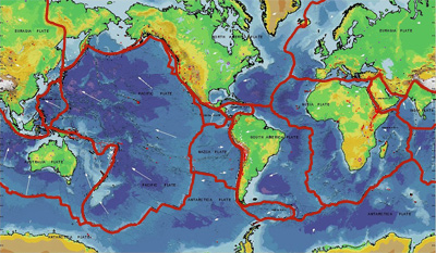
The earthquake happened as Earth's tectonic plates moved along the boundary between the Nazca and South American tectonic plates. These two plates are moving towards each other over time. Each year, they move about 8 cm (3.2 in) closer. Where does the extra rock go? The Nazca plate is sliding below the South American plate, a process called subduction.
This is not the first earthquake to rock coastal Chile. Because it is so close to the boundary between two tectonic plates, the area has a long history of earthquakes. Thirteen large earthquakes, magnitude 7.0 or higher, have shaken the area since 1973. Because it is so prone to earthquakes, there are strict building codes in this area, which means that buildings are designed to be sturdy. Thus, even though this earthquake was much stronger than the earthquake that struck Haiti a month ago, the total destruction is likely to be much less.
The earthquake created tsunami waves in the Pacific Ocean of up to 2.35 meters (7.7 ft), which flooded islands and threw boats into houses along the coast at Talcahuano, Chile. The Pacific Tsunami Warning Center issued a warning that countries in and around the Pacific Ocean, even those thousands of miles away in the western Pacific, should prepare for the possibility that tsunami waves would soon reach their coasts. The Center monitors sea level in the Pacific to track the location of tsunami waves as they move across he ocean. Sirens blasted in the early morning on the Hawaiian Islands, warning people to go to higher ground. Thankfully, the tsunami was quite small when it hit most areas - about 1.2 meters (4 ft) high in Japan and about 2 meters (6.5 feet) high on Tonga and New Zealand.