An image of Hurricane Sandy taken by the GOES-13 satellite on October 28. This category 1 hurricane was huge, spanning a horizontal distance of about one-third the US continental landmass. The storm came onshore in New Jersey, and gradually moved northeast. The storm disrupted the lives of tens of millions in the eastern US, doing billions of dollars in damage, resulting in over 30 deaths. Visit the National Hurricane Center's webpage on Hurricane Sandy for details.
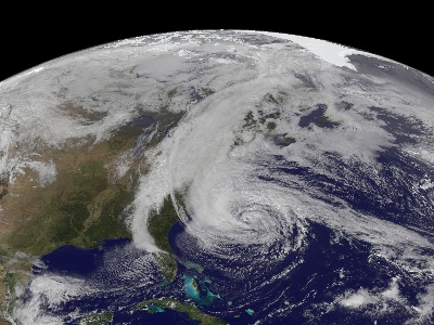
Click on image for full size
Image courtesy of NASA

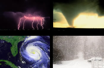
Hurricanes (also known as Tropical Cyclones)

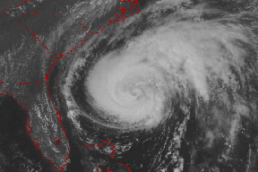
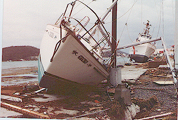
As a strong hurricane heads towards a vulnerable coast, people take precautions - boarding up houses, packing the car, and evacuating. These massive storms can spell disaster for people in hurricane prone areas, so they are taken seriously. They are the most powerful of all weather systems and they are huge - 340 miles in diameter on average.

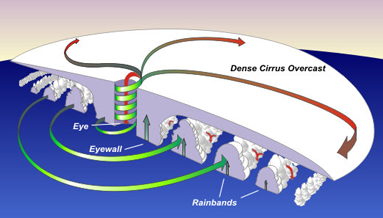
Hurricanes form in the tropics over warm ocean water and die down when they move over land or into higher latitudes. These storms are called hurricanes in the Atlantic and typhoons or tropical cyclones in other areas of the world. In the Northern Hemisphere the storms rotate counterclockwise and in the Southern Hemisphere they rotate clockwise due to the Coriolis Effect. At the center of the rotating storm is a small area of calm weather and clear skies called the eye. While the eye may be calm, the area directly around it - called the eyewall - is often the most dangerous part of the storm.

Hurricane damage in coastal areas is often due to storm surge, which floods coastal areas. Strong waves and wind also batter coastal areas. Hurricanes also cause a tremendous amount of rain. Not all storms are the same. Large and strong storms cause much more damage than small storms. Scales are used to describe the size of a hurricane. In the Atlantic and Eastern Pacific, the Saffir-Simpson Hurricane Scale is used.

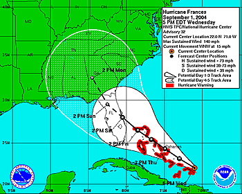
As hurricanes move, meteorologists try to forecast where and when the storm will reach land in order to warn people. Hurricanes are tracked over large distances with weather satellites. To forecast where the storm will go, meteorologists use computer models that take into account factors of the storm and the atmosphere. Since 1953 each hurricane has been given a name to help warn people that a storm was on its way.

In the North Atlantic, hurricanes typically happen between June 1st and November 30th. This is known as hurricane season. More hurricanes form in the North Atlantic between August and September than any other time of year. Other regions of the world have somewhat different timing of hurricane season, but in all areas the season overlaps with the summer months when the warmest temperatures fuel the powerful storms.

Last modified April 29, 2016 by Jennifer Bergman.

You might also be interested in:

Traveling Nitrogen Classroom Activity Kit

Check out our online store - minerals, fossils, books, activities, jewelry, and household items!...more

The Eye of a Hurricane

At the center of a fierce tropical storm, there is a small area where the weather is calm, the sky is clear, and the winds are just light breezes. This area is called the eye of the storm. As a hurricane...more

Wind

Wind is moving air. Warm air rises, and cool air comes in to take its place. This movement creates different pressures in the atmosphere which creates the winds around the globe. Since the Earth spins,...more

Hurricane Forecasting Uses Climate Data to Predict the Season, and Weather Data to Predict a Storm’s Path

Each year scientists make predictions about the strength of the upcoming hurricane season. To make seasonal hurricane predictions, scientists look at climate models and climate events that are known to...more

Good News from the 1998 Hurricane Season

The Atlantic hurricane season was active this year with 14 named storms and 10 hurricanes. (This was above the average of 10 named storms and 6 hurricanes.) The storms killed over 11,000 people and caused...more

What is "Tornado Alley"?

The land which stretches from Texas to Manitoba is relatively flat, most of which is part of the Great Plains in the United States. The flat land is a good breeding ground for the storms which produce...more

Examples of Advisories, Watches, and Warnings for Weather Events

Below is a list of some weather conditions that call for an advisory, watch, or warning. Heat Advisory/Warning: A heat advisory is issued when the daytime temperature will be 105ºF (40.6ºC) for three hours...more

Hurricane Bonnie Update

From the National Weather Service, Miami, Florida, 11 a.m. EDT: Bonnie battering coastal North Carlina...Flood threat from rain increasing...Hurricane warnings remain in effect from Cape Romain, South...more

Windows to the Universe, a project of the National Earth Science Teachers Association, is sponsored in part is sponsored in part through grants from federal agencies (NASA and NOAA), and partnerships with affiliated organizations, including the American Geophysical Union, the Howard Hughes Medical Institute, the Earth System Information Partnership, the American Meteorological Society, the National Center for Science Education, and TERC. The American Geophysical Union and the American Geosciences Institute are Windows to the Universe Founding Partners. NESTA welcomes new Institutional Affiliates in support of our ongoing programs, as well as collaborations on new projects. Contact NESTA for more information. NASA ESIP NCSE HHMI AGU AGI AMS NOAA